


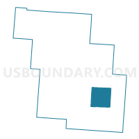
PLEASANT Voting District, Perry County, Ohio
About
Outline

Summary
| Unique Area Identifier | 650943 |
| Name | PLEASANT Voting District |
| County | Perry County |
| State | Ohio |
| Area (square miles) | 16.21 |
| Land Area (square miles) | 15.95 |
| Water Area (square miles) | 0.26 |
| % of Land Area | 98.40 |
| % of Water Area | 1.60 |
| Latitude of the Internal Point | 39.65554700 |
| Longtitude of the Internal Point | -82.12373550 |
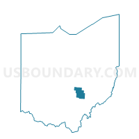
Maps

Graphs
Select a template below for downloading or customizing gragh for PLEASANT Voting District, Perry County, Ohio


Neighbors
Neighoring Voting District (by Name) Neighboring Voting District on the Map
- BEARFIELD EAST Voting District, Perry County, OH
- BEARFIELD WEST Voting District, Perry County, OH
- MONROE Voting District, Perry County, OH
- PIKE SOUTH Voting District, Perry County, OH
- PIKE WEST Voting District, Perry County, OH
- SALTLICK Voting District, Perry County, OH
Top 10 Neighboring County Subdivision (by Population) Neighboring County Subdivision on the Map
- Pike township, Perry County, OH (6,923)
- Bearfield township, Perry County, OH (1,677)
- Monroe township, Perry County, OH (1,508)
- Salt Lick township, Perry County, OH (1,262)
- Pleasant township, Perry County, OH (846)
Top 10 Neighboring Unified School District (by Population) Neighboring Unified School District on the Map
- New Lexington City School District, OH (11,078)
- Crooksville Exempted Village School District, OH (5,491)
- Southern Local School District, OH (4,814)